Title:
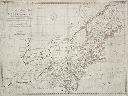
“A New and Accurate Map of Part of North America, Comprehending the Provinces of New England, New York, Pensilvania, New Yersey, Connecticut, Rhode Island, & part of Virginia, Canada, and Hallifax”
Map Maker:
Pieter Kalm
Scarce map covering Virginia through New England, ... (full text available to subscribers)
| Item Detail |
| |
| |
MapMaker: |
Pieter Kalm
|
|
| |
| |
Subject: |
Colonial North America |
|
| |
Period/Size: |
1771 / 22.2" x 29.8" (56.4 x 75.7 cm)
|
|
| |
Color: |
Black & White
|
|
| |
Condition: |
(A) Issued folded with close margins at top and at binding side. Now flattened with margins extended and a few fold intersection repaired with tissue. (condition help) |
|
| |
Source: |
Travels into North America ģ |
|
| |
References: |
McKorkle #770.1; Seller & Van Ee #726; Sabin #36989. |
|
| |
|
|
| Sales Information |
| |
| |
Price: |
|
|
| |
| |
Offered by: |
Old World Auctions |
|
| |
Catalog: |
Auction No. 96 - Antique Maps, Charts, Atlases & Globes (168) |
|
| |
Lot/Item #: |
118 |
|
| |
| |
Date: |
09/2001
|
|
| |
| |
|
Antique Maps - Valuation and Pricing, Descriptions, Resources |
|
Home |
Information |
Search |
Register |
Contact Us |
Site Map
Americana Exchange, Inc. © 1999 - 2024 Americana Exchange, Inc.. All rights reserved.
OldMaps.com, the OldMaps.com logo and
AMPR are service marks or registered service marks of Americana Exchange, Inc..
|