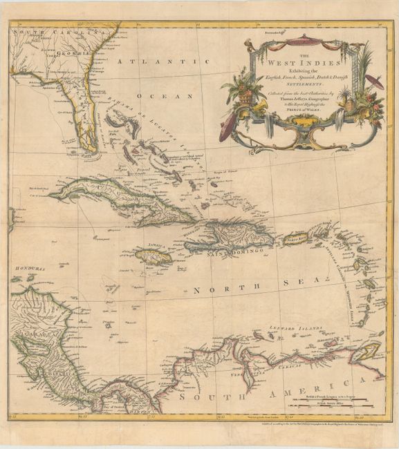
Title:
“The West Indies Exhibiting the English, French, Spanish, Dutch & Danish Settlements”
Map Maker:
Thomas Jefferys
This is an uncommon map of the Caribbean showing t... (full text available to subscribers)
| Item Detail |
| |
| |
MapMaker: |
Thomas Jefferys
|
|
| |
| |
Subject: |
Caribbean |
|
| |
Period/Size: |
1760 / 18.4" x 17.7" (46.8 x 45.0 cm)
|
|
| |
Color: |
Colored
|
|
| |
Condition: |
(B+) A nice impression, issued folding, now pressed with light offsetting and a few fold separations that have been professionally repaired. There is a binding tear at right that enters 1.5" into image that has also been professionally repaired. (condition help) |
|
| |
Source: |
The Natural and Civil History of the French Dominions in North and South America |
|
| |
References: |
Shirley (BL Atlases) G.JEF-1a #9. |
|
| |
|
|
| Sales Information |
| |
| |
Price: |
|
|
| |
| |
Offered by: |
Old World Auctions |
|
| |
Catalog: |
Auction No. 148 - Antique Maps, Charts, Atlases & Globes (9227) |
|
| |
Lot/Item #: |
371 |
|
| |
| |
Date: |
02/2014
|
|
| |
| |
|
Antique Maps - Valuation and Pricing, Descriptions, Resources |
|
Home |
Information |
Search |
Register |
Contact Us |
Site Map
Americana Exchange, Inc. © 1999 - 2024 Americana Exchange, Inc.. All rights reserved.
OldMaps.com, the OldMaps.com logo and
AMPR are service marks or registered service marks of Americana Exchange, Inc..
|