Title:
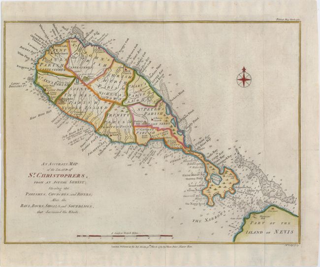
“An Accurate Map of the Island of St. Christophers, from an Actual Survey Shewing the Parishes, Churches, and Rivers...”
Map Maker:
John Bew
Handsome map of this Leeward island with detail of... (full text available to subscribers)
| Item Detail |
| |
| |
MapMaker: |
John Bew
|
|
| |
| |
Subject: |
St. Kitts |
|
| |
Period/Size: |
1782 / 10.9" x 14.5" (27.7 x 36.9 cm)
|
|
| |
Color: |
Colored
|
|
| |
Condition: |
(B+) Issued folding, now pressed on watermarked paper with minor soiling and offsetting and a narrow left margin. (condition help) |
|
| |
Source: |
Political Magazine |
|
| |
References: |
Tooley (MCC-81) St. Christopher #52. |
|
| |
|
|
| Sales Information |
| |
| |
Price: |
|
|
| |
| |
Offered by: |
Old World Auctions |
|
| |
Catalog: |
Auction No. 148 - Antique Maps, Charts, Atlases & Globes (9227) |
|
| |
Lot/Item #: |
385 |
|
| |
| |
Date: |
02/2014
|
|
| |
| |
|
Antique Maps - Valuation and Pricing, Descriptions, Resources |
|
Home |
Information |
Search |
Register |
Contact Us |
Site Map
Americana Exchange, Inc. © 1999 - 2024 Americana Exchange, Inc.. All rights reserved.
OldMaps.com, the OldMaps.com logo and
AMPR are service marks or registered service marks of Americana Exchange, Inc..
|