Title:
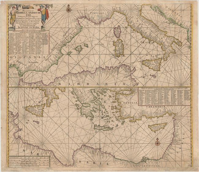
“Pas-caart van de Middellandsche Zee, Verthoonende Alle de Zee-kusten van Granaden, Catalonien, Provencen Italien...”
Map Maker:
Johannes van Keulen
This rare sheet depicts the entire Mediterranean, ... (full text available to subscribers)
| Item Detail |
| |
| |
MapMaker: |
Johannes van Keulen
|
|
| |
| |
Subject: |
Mediterranean |
|
| |
Period/Size: |
1728 / 20.8" x 23.5" (52.9 x 59.7 cm)
|
|
| |
Color: |
Colored
|
|
| |
Condition: |
(B+) A nice impression with a professionally repaired hole near centerfold at bottom of map. Numerous chips in the bottom blank margin have also been professionally repaired, a few of which just enter the neatline. (condition help) |
|
| |
Source: |
|
|
| |
References: |
|
|
| |
|
|
| Sales Information |
| |
| |
Price: |
|
|
| |
| |
Offered by: |
Old World Auctions |
|
| |
Catalog: |
Auction No. 148 - Antique Maps, Charts, Atlases & Globes (9227) |
|
| |
Lot/Item #: |
589 |
|
| |
| |
Date: |
02/2014
|
|
| |
| |
|
Antique Maps - Valuation and Pricing, Descriptions, Resources |
|
Home |
Information |
Search |
Register |
Contact Us |
Site Map
Americana Exchange, Inc. © 1999 - 2024 Americana Exchange, Inc.. All rights reserved.
OldMaps.com, the OldMaps.com logo and
AMPR are service marks or registered service marks of Americana Exchange, Inc..
|