Title:
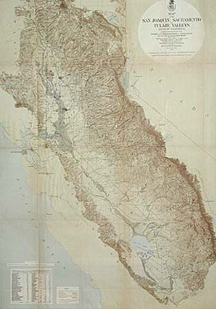
“Map of the San Joaquin, Sacramento and Tulares Valleys, State of California”
Map Maker:
Government Maps: Local & State
A large and interesting map of the "waterways" of ... (full text available to subscribers)
| Item Detail |
| |
| |
MapMaker: |
Government Maps: Local & State
|
|
| |
| |
Subject: |
California |
|
| |
Period/Size: |
1873 / 34.0" x 24.0" (86.4 x 61.0 cm)
|
|
| |
Color: |
Colored
|
|
| |
Condition: |
(A) Attractive color. Issued folded and now back with Japanese tissue. Faint toning of folds, but overall very good. (condition help) |
|
| |
Source: |
Board of Commissioners on Irrigation |
|
| |
References: |
|
|
| |
|
|
| Sales Information |
| |
| |
Price: |
|
|
| |
| |
Offered by: |
Old World Auctions |
|
| |
Catalog: |
Auction No. 96 - Antique Maps, Charts, Atlases & Globes (168) |
|
| |
Lot/Item #: |
157 |
|
| |
| |
Date: |
09/2001
|
|
| |
| |
|
Antique Maps - Valuation and Pricing, Descriptions, Resources |
|
Home |
Information |
Search |
Register |
Contact Us |
Site Map
Americana Exchange, Inc. © 1999 - 2024 Americana Exchange, Inc.. All rights reserved.
OldMaps.com, the OldMaps.com logo and
AMPR are service marks or registered service marks of Americana Exchange, Inc..
|