Title:
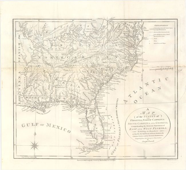
“A Map of the States of Virginia, North Carolina, South Carolina and Georgia; Comprehending the Spanish Provinces of East and West Florida...”
Map Maker:
Joseph Purcell
This fine map is a fascinating historical document... (full text available to subscribers)
| Item Detail |
| |
| |
MapMaker: |
Joseph Purcell
|
|
| |
| |
Subject: |
Southeast United States |
|
| |
Period/Size: |
1792 / 12.5" x 14.4" (31.8 x 36.6 cm)
|
|
| |
Color: |
Black & White
|
|
| |
Condition: |
(B) A crisp impression issued folding, now flattened, with several fold separations and edge tears that have been archivally repaired with a minute amount of image missing. (condition help) |
|
| |
Source: |
Morse's Geography |
|
| |
References: |
Baynton-Williams (TMC-72) p. 15, #4; Sellers & Van Ee #1410; Wheat & Brun #491. |
|
| |
|
|
| Sales Information |
| |
| |
Price: |
|
|
| |
| |
Offered by: |
Old World Auctions |
|
| |
Catalog: |
Auction No. 149 - Antique Maps, Charts, Atlases & Globes (9228) |
|
| |
Lot/Item #: |
161 |
|
| |
| |
Date: |
05/2014
|
|
| |
| |
|
Antique Maps - Valuation and Pricing, Descriptions, Resources |
|
Home |
Information |
Search |
Register |
Contact Us |
Site Map
Americana Exchange, Inc. © 1999 - 2024 Americana Exchange, Inc.. All rights reserved.
OldMaps.com, the OldMaps.com logo and
AMPR are service marks or registered service marks of Americana Exchange, Inc..
|