Title:
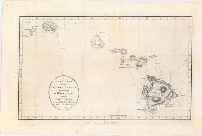
“A New Chart of the Sandwich Islands; Including Owhyhee, Where Captn. Cooke Was Killed on Sunday the 14th of February 1779”
Map Maker:
John E. Harrison
This uncommon chart is Harrison's version of Henry... (full text available to subscribers)
| Item Detail |
| |
| |
MapMaker: |
John E. Harrison
|
|
| |
| |
Subject: |
Hawaii |
|
| |
Period/Size: |
1784 / 7.9" x 12.6" (20.1 x 32.0 cm)
|
|
| |
Color: |
Black & White
|
|
| |
Condition: |
(A) Issued folding on watermarked paper with a couple of short fold separations, well away from the image. (condition help) |
|
| |
Source: |
The Geographical Magazine… |
|
| |
References: |
McCorkle (18th C. Geography Books) #268-23; Shirley (BL Atlases) G.MRT-1a #30. |
|
| |
|
|
| Sales Information |
| |
| |
Price: |
|
|
| |
| |
Offered by: |
Old World Auctions |
|
| |
Catalog: |
Auction No. 149 - Antique Maps, Charts, Atlases & Globes (9228) |
|
| |
Lot/Item #: |
237 |
|
| |
| |
Date: |
05/2014
|
|
| |
| |
|
Antique Maps - Valuation and Pricing, Descriptions, Resources |
|
Home |
Information |
Search |
Register |
Contact Us |
Site Map
Americana Exchange, Inc. © 1999 - 2024 Americana Exchange, Inc.. All rights reserved.
OldMaps.com, the OldMaps.com logo and
AMPR are service marks or registered service marks of Americana Exchange, Inc..
|