Title:
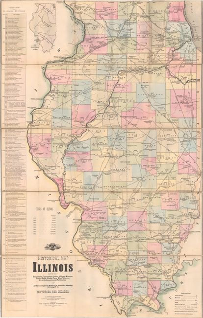
“Historical Map of Illinois Showing Early Discoveries, Explorations, Indian Villages, Missions, Trails, Battle Fields, Forts, Block Houses, First Settlements and Mail Routes...”
Map Maker:
Rufus Blanchard
This uncommon map of Illinois outlines the history... (full text available to subscribers)
| Item Detail |
| |
| |
MapMaker: |
Rufus Blanchard
|
|
| |
| |
Subject: |
Illinois |
|
| |
Period/Size: |
1883 / 42.5" x 27.4" (108.0 x 69.6 cm)
|
|
| |
Color: |
Colored
|
|
| |
Condition: |
(B) The map is good with bright, original color and light soiling along a few folds. Trimmed at top and bottom with complete loss of border, as issued. The map is separating from the linen in numerous places. The book is in very good condition, with a (condition help) |
|
| |
Source: |
History of Illinois... |
|
| |
References: |
Howes #B510. |
|
| |
|
|
| Sales Information |
| |
| |
Price: |
|
|
| |
| |
Offered by: |
Old World Auctions |
|
| |
Catalog: |
Auction No. 149 - Antique Maps, Charts, Atlases & Globes (9228) |
|
| |
Lot/Item #: |
239 |
|
| |
| |
Date: |
05/2014
|
|
| |
| |
|
Antique Maps - Valuation and Pricing, Descriptions, Resources |
|
Home |
Information |
Search |
Register |
Contact Us |
Site Map
Americana Exchange, Inc. © 1999 - 2024 Americana Exchange, Inc.. All rights reserved.
OldMaps.com, the OldMaps.com logo and
AMPR are service marks or registered service marks of Americana Exchange, Inc..
|