Title:
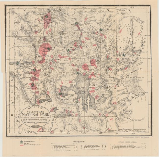
“Map of the Yellowstone National Park Compiled from the Official Explorations & Surveys of the Superintendent of the Park...”
Map Maker:
Thomas Donaldson
This map is from the 5th Annual Report of P.W. Nor... (full text available to subscribers)
| Item Detail |
| |
| |
MapMaker: |
Thomas Donaldson
|
|
| |
| |
Subject: |
Yellowstone, Wyoming |
|
| |
Period/Size: |
1881 / 15.3" x 17.2" (38.9 x 43.7 cm)
|
|
| |
Color: |
Colored
|
|
| |
Condition: |
(B+) Issued folding with a 6" separation along one fold that has been closed on verso with archival tape. There is a binding trim at left and an associated binding tear that just enters the neatline and has also been closed on verso with archival tape. (condition help) |
|
| |
Source: |
Public Domain |
|
| |
References: |
|
|
| |
|
|
| Sales Information |
| |
| |
Price: |
|
|
| |
| |
Offered by: |
Old World Auctions |
|
| |
Catalog: |
Auction No. 149 - Antique Maps, Charts, Atlases & Globes (9228) |
|
| |
Lot/Item #: |
302 |
|
| |
| |
Date: |
05/2014
|
|
| |
| |
|
Antique Maps - Valuation and Pricing, Descriptions, Resources |
|
Home |
Information |
Search |
Register |
Contact Us |
Site Map
Americana Exchange, Inc. © 1999 - 2024 Americana Exchange, Inc.. All rights reserved.
OldMaps.com, the OldMaps.com logo and
AMPR are service marks or registered service marks of Americana Exchange, Inc..
|