| Item Detail |
| |
| |
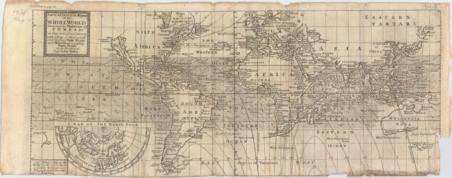
MapMaker: |
Edmund Halley
|
|
| |
| |
Subject: |
World |
|
| |
Period/Size: |
1710 / 7.7" x 18.9" (19.6 x 48.0 cm)
|
|
| |
Color: |
Black & White
|
|
| |
Condition: |
(B) Issued folding and trimmed to the neatline at bottom, with a few small portions of the neatline missing. There is a binding trim at lower right and associated 0.5" binding tear. Light soiling with a few chips and fold separations at top and bottom. (condition help) |
|
| |
Source: |
Miscellanea Curiosa… |
|
| |
References: |
cf. Shirley (BL Atlases) M.Hall-1a #1 & #2. |
|
| |
|
|
| Sales Information |
| |
| |
Price: |
|
|
| |
| |
Offered by: |
Old World Auctions |
|
| |
Catalog: |
Auction No. 150 - Antique Maps, Charts, Atlases & Globes (9230) |
|
| |
Lot/Item #: |
28 |
|
| |
| |
Date: |
09/2014
|
|
| |
| |
|