Title:
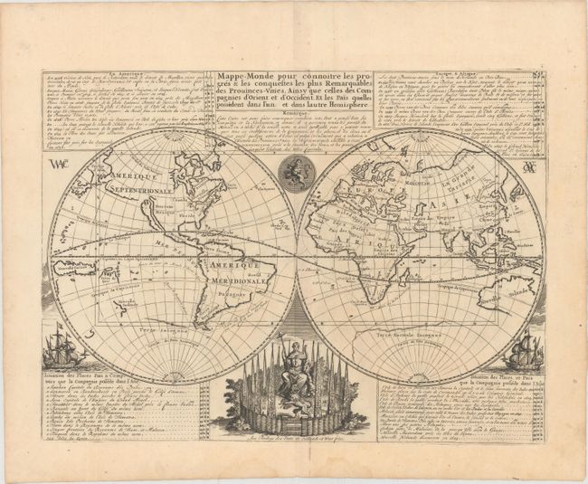
“Mappe-Monde pour Connoitre les Progres & les Conquestes les Plus Remarquables des Provinces-Unies, Ainsy que Celles des Compagnies d'Orient et d'Occident, et les Pais Quelles Possedent dans l'un et dans Lautre Hemisphere”
Map Maker:
Henry Abraham Chatelain
The voyages and discoveries of the Dutch East Indi... (full text available to subscribers)
| Item Detail |
| |
| |
MapMaker: |
Henry Abraham Chatelain
|
|
| |
| |
Subject: |
World |
|
| |
Period/Size: |
1720 / 13.2" x 18.0" (33.6 x 45.8 cm)
|
|
| |
Color: |
Black & White
|
|
| |
Condition: |
(B+) A dark impression on a watermarked sheet with faint toning, minor offsetting, and a few small spots. There are damp stains confined to the bottom blank margin. (condition help) |
|
| |
Source: |
Atlas Historique |
|
| |
References: |
Shirley #447. |
|
| |
|
|
| Sales Information |
| |
| |
Price: |
|
|
| |
| |
Offered by: |
Old World Auctions |
|
| |
Catalog: |
Auction No. 150 - Antique Maps, Charts, Atlases & Globes (9230) |
|
| |
Lot/Item #: |
30 |
|
| |
| |
Date: |
09/2014
|
|
| |
| |
|
Antique Maps - Valuation and Pricing, Descriptions, Resources |
|
Home |
Information |
Search |
Register |
Contact Us |
Site Map
Americana Exchange, Inc. © 1999 - 2024 Americana Exchange, Inc.. All rights reserved.
OldMaps.com, the OldMaps.com logo and
AMPR are service marks or registered service marks of Americana Exchange, Inc..
|