Title:
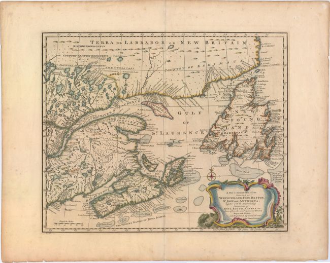
“A New & Accurate Map of the Islands of Newfoundland, Cape Briton, St. John and Anticosta; Together with the Neighbouring Countries of Nova Scotia, Canada &c. Drawn from the Most Approved Moderns Maps and Charts, and Regulated by Astronl. Observatns.”
Map Maker:
Emanuel Bowen
An attractive map of the Gulf of St. Laurence base... (full text available to subscribers)
| Item Detail |
| |
| |
MapMaker: |
Emanuel Bowen
|
|
| |
| |
Subject: |
Eastern Canada |
|
| |
Period/Size: |
1752 / 13.7" x 16.8" (34.8 x 42.7 cm)
|
|
| |
Color: |
Colored
|
|
| |
Condition: |
(B+) A nice impression on watermarked paper with wide margins and light soiling. (condition help) |
|
| |
Source: |
A Complete Atlas, or Distinct View of the Known World |
|
| |
References: |
Kershaw #694; Phillips (A) #614-41. |
|
| |
|
|
| Sales Information |
| |
| |
Price: |
|
|
| |
| |
Offered by: |
Old World Auctions |
|
| |
Catalog: |
Auction No. 150 - Antique Maps, Charts, Atlases & Globes (9230) |
|
| |
Lot/Item #: |
110 |
|
| |
| |
Date: |
09/2014
|
|
| |
| |
|
Antique Maps - Valuation and Pricing, Descriptions, Resources |
|
Home |
Information |
Search |
Register |
Contact Us |
Site Map
Americana Exchange, Inc. © 1999 - 2024 Americana Exchange, Inc.. All rights reserved.
OldMaps.com, the OldMaps.com logo and
AMPR are service marks or registered service marks of Americana Exchange, Inc..
|