Title:
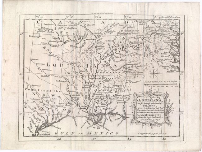
“Louisiana, as Formerly Claimed by France, Now Containing Part of British America to the East & Spanish America to the West of the Mississipi. From the Best Authorities”
Map Maker:
Thomas Kitchin
This well-engraved map focuses on the Mississippi ... (full text available to subscribers)
| Item Detail |
| |
| |
MapMaker: |
Thomas Kitchin
|
|
| |
| |
Subject: |
Colonial Southern United States |
|
| |
Period/Size: |
1765 / 7.0" x 9.1" (17.8 x 23.2 cm)
|
|
| |
Color: |
Black & White
|
|
| |
Condition: |
(B+) Issued folding with minor soiling and several mis-folds. (condition help) |
|
| |
Source: |
London Magazine |
|
| |
References: |
Sellers & Van Ee #724; Jolly #LOND-245; Lemmon, Magill & Wiese, Charting Louisiana #39. |
|
| |
|
|
| Sales Information |
| |
| |
Price: |
|
|
| |
| |
Offered by: |
Old World Auctions |
|
| |
Catalog: |
Auction No. 150 - Antique Maps, Charts, Atlases & Globes (9230) |
|
| |
Lot/Item #: |
188 |
|
| |
| |
Date: |
09/2014
|
|
| |
| |
|
Antique Maps - Valuation and Pricing, Descriptions, Resources |
|
Home |
Information |
Search |
Register |
Contact Us |
Site Map
Americana Exchange, Inc. © 1999 - 2024 Americana Exchange, Inc.. All rights reserved.
OldMaps.com, the OldMaps.com logo and
AMPR are service marks or registered service marks of Americana Exchange, Inc..
|