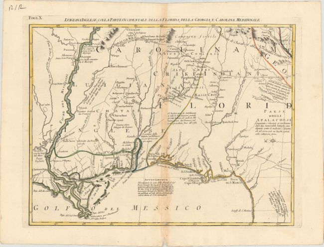
Title:
“Luigiana Inglese, colla Parte Occidentale della Florida, della Giorgia, e Carolina Meridonale”
Map Maker:
Antonio Zatta
This map provides a great regional description of ... (full text available to subscribers)
| Item Detail |
| |
| |
MapMaker: |
Antonio Zatta
|
|
| |
| |
Subject: |
Colonial Southern United States |
|
| |
Period/Size: |
1778 / 12.5" x 16.5" (31.8 x 42.0 cm)
|
|
| |
Color: |
Colored
|
|
| |
Condition: |
(B) Original outline color on watermarked paper with moderate toning along the centerfold and a few worm tracks also along the centerfold. (condition help) |
|
| |
Source: |
Atlante Novissimo… |
|
| |
References: |
Portinaro & Knirsch, plt. CLII; Sellers and Van Ee #163. |
|
| |
|
|
| Sales Information |
| |
| |
Price: |
|
|
| |
| |
Offered by: |
Old World Auctions |
|
| |
Catalog: |
Auction No. 150 - Antique Maps, Charts, Atlases & Globes (9230) |
|
| |
Lot/Item #: |
189 |
|
| |
| |
Date: |
09/2014
|
|
| |
| |
|
Antique Maps - Valuation and Pricing, Descriptions, Resources |
|
Home |
Information |
Search |
Register |
Contact Us |
Site Map
Americana Exchange, Inc. © 1999 - 2024 Americana Exchange, Inc.. All rights reserved.
OldMaps.com, the OldMaps.com logo and
AMPR are service marks or registered service marks of Americana Exchange, Inc..
|