Title:
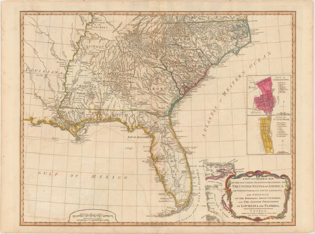
“A New and General Map of the Southern Dominions Belonging to the United States of America, viz North Carolina, South Carolina, and Georgia: with the Bordering Indian Countries, and the Spanish Possessions of Louisiana and Florida”
Map Maker:
Laurie & Whittle
This is the second edition of this important map t... (full text available to subscribers)
| Item Detail |
| |
| |
MapMaker: |
Laurie & Whittle
|
|
| |
| |
Subject: |
Southeast United States |
|
| |
Period/Size: |
1794 / 19.7" x 25.3" (50.1 x 64.3 cm)
|
|
| |
Color: |
Colored
|
|
| |
Condition: |
(B+) There is light toning and offsetting, some soiling, and a few tiny holes along the centerfold. (condition help) |
|
| |
Source: |
|
|
| |
References: |
Tooley (Amer) pp. 98-9, #78-b. |
|
| |
|
|
| Sales Information |
| |
| |
Price: |
|
|
| |
| |
Offered by: |
Old World Auctions |
|
| |
Catalog: |
Auction No. 150 - Antique Maps, Charts, Atlases & Globes (9230) |
|
| |
Lot/Item #: |
179 |
|
| |
| |
Date: |
09/2014
|
|
| |
| |
|
Antique Maps - Valuation and Pricing, Descriptions, Resources |
|
Home |
Information |
Search |
Register |
Contact Us |
Site Map
Americana Exchange, Inc. © 1999 - 2024 Americana Exchange, Inc.. All rights reserved.
OldMaps.com, the OldMaps.com logo and
AMPR are service marks or registered service marks of Americana Exchange, Inc..
|