Title:
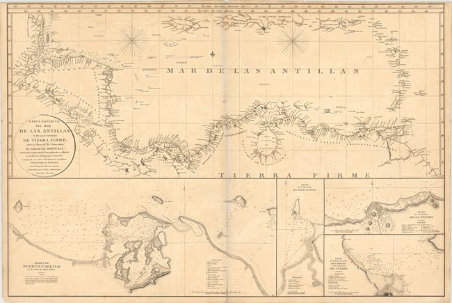
“Carta Esferica del Mar de las Antillas y de las Costas de Tierra Firme, Desde las Bocas del Rio Orinoco Hasta el Golfo de Honduras...”
Map Maker:
Direccion de Hidrografia
This large-scale chart depicts the coastlines surr... (full text available to subscribers)
| Item Detail |
| |
| |
MapMaker: |
Direccion de Hidrografia
|
|
| |
| |
Subject: |
Northern South America and Caribbean |
|
| |
Period/Size: |
1810 / 25.5" x 37.8" (64.8 x 96.1 cm)
|
|
| |
Color: |
Black & White
|
|
| |
Condition: |
(B) A dark impression with some offsetting, light toning along centerfold and top edge of sheet, and a centerfold separation that enters 1" into map at bottom. There is an archivally repaired tear that enters 1.5" into a blank area of Puerto Cabello inse (condition help) |
|
| |
Source: |
|
|
| |
References: |
|
|
| |
|
|
| Sales Information |
| |
| |
Price: |
|
|
| |
| |
Offered by: |
Old World Auctions |
|
| |
Catalog: |
Auction No. 150 - Antique Maps, Charts, Atlases & Globes (9230) |
|
| |
Lot/Item #: |
363 |
|
| |
| |
Date: |
09/2014
|
|
| |
| |
|
Antique Maps - Valuation and Pricing, Descriptions, Resources |
|
Home |
Information |
Search |
Register |
Contact Us |
Site Map
Americana Exchange, Inc. © 1999 - 2024 Americana Exchange, Inc.. All rights reserved.
OldMaps.com, the OldMaps.com logo and
AMPR are service marks or registered service marks of Americana Exchange, Inc..
|