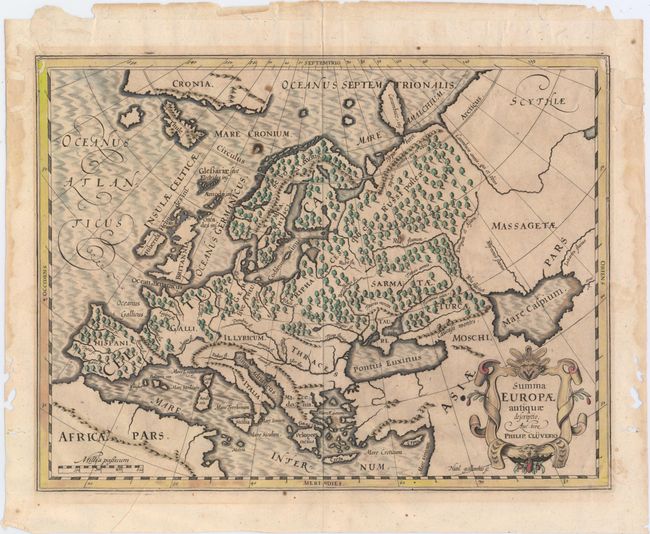
Title:
“Summa Europae Antiquae Descriptio”
Map Maker:
Philipp Cluver
This map of Europe shows its ancient divisions, as... (full text available to subscribers)
| Item Detail |
| |
| |
MapMaker: |
Philipp Cluver
|
|
| |
| |
Subject: |
Europe |
|
| |
Period/Size: |
1616 / 10.6" x 13.9" (27.0 x 35.3 cm)
|
|
| |
Color: |
Colored
|
|
| |
Condition: |
(B) A nice impression on a watermarked sheet with two small worm holes in the image and worm tracks in the upper left and right border which have all been repaired with old paper with a tiny portion of the image in facsimile. (condition help) |
|
| |
Source: |
Philippi Cluveri Germaniae Antique Libri Tres... |
|
| |
References: |
Shirley (BL Atlases) T.CLUV-1a #3. |
|
| |
|
|
| Sales Information |
| |
| |
Price: |
|
|
| |
| |
Offered by: |
Old World Auctions |
|
| |
Catalog: |
Auction No. 150 - Antique Maps, Charts, Atlases & Globes (9230) |
|
| |
Lot/Item #: |
401 |
|
| |
| |
Date: |
09/2014
|
|
| |
| |
|
Antique Maps - Valuation and Pricing, Descriptions, Resources |
|
Home |
Information |
Search |
Register |
Contact Us |
Site Map
Americana Exchange, Inc. © 1999 - 2024 Americana Exchange, Inc.. All rights reserved.
OldMaps.com, the OldMaps.com logo and
AMPR are service marks or registered service marks of Americana Exchange, Inc..
|