Title:
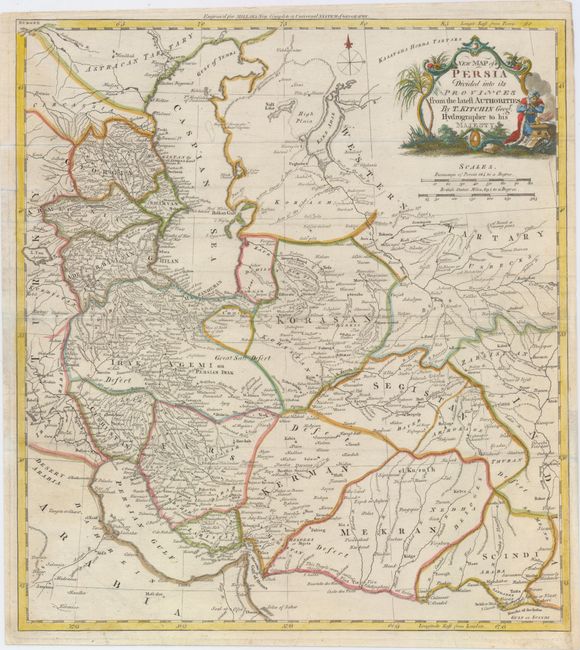
“New Map of Persia Divided into its Provinces from the Latest Authorities”
Map Maker:
Thomas Kitchin
This attractive map covers the Persian Empire, whi... (full text available to subscribers)
| Item Detail |
| |
| |
MapMaker: |
Thomas Kitchin
|
|
| |
| |
Subject: |
Persia & the Caucasus |
|
| |
Period/Size: |
1782 / 15.0" x 13.5" (38.1 x 34.3 cm)
|
|
| |
Color: |
Colored
|
|
| |
Condition: |
(B+) Issued folding with one archivally repaired fold separation and a few minute worm holes only visible when held to light. A binding trim at bottom right has been replaced with old paper to accommodate framing. (condition help) |
|
| |
Source: |
Millar's New Complete & Universal System of Geography |
|
| |
References: |
|
|
| |
|
|
| Sales Information |
| |
| |
Price: |
|
|
| |
| |
Offered by: |
Old World Auctions |
|
| |
Catalog: |
Auction No. 150 - Antique Maps, Charts, Atlases & Globes (9230) |
|
| |
Lot/Item #: |
595 |
|
| |
| |
Date: |
09/2014
|
|
| |
| |
|
Antique Maps - Valuation and Pricing, Descriptions, Resources |
|
Home |
Information |
Search |
Register |
Contact Us |
Site Map
Americana Exchange, Inc. © 1999 - 2024 Americana Exchange, Inc.. All rights reserved.
OldMaps.com, the OldMaps.com logo and
AMPR are service marks or registered service marks of Americana Exchange, Inc..
|