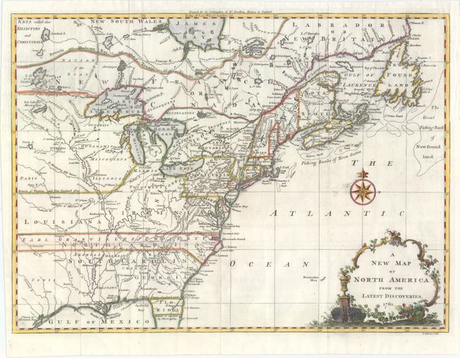
Title:
“A New Map of North America from the Latest Discoveries”
Map Maker:
John Spilsbury
This is the uncommon first state, not the 1763 edi... (full text available to subscribers)
| Item Detail |
| |
| |
MapMaker: |
John Spilsbury
|
|
| |
| |
Subject: |
Colonial Eastern United States & Canada |
|
| |
Period/Size: |
1761 / 10.8" x 14.8" (27.5 x 37.6 cm)
|
|
| |
Color: |
Colored
|
|
| |
Condition: |
(A) Issued folding on watermarked paper with a few spots of printer's ink residue. A binding trim at right has been replaced with old paper, and an associated 1" binding tear has been closed on verso with archival tape. (condition help) |
|
| |
Source: |
The Continuation of Dr. Smollett's History of England |
|
| |
References: |
McCorkle #761-3; Sellers & Van Ee #89. |
|
| |
|
|
| Sales Information |
| |
| |
Price: |
|
|
| |
| |
Offered by: |
Old World Auctions |
|
| |
Catalog: |
Auction No. 151 - Antique Maps, Charts, Atlases & Globes (9260) |
|
| |
Lot/Item #: |
113 |
|
| |
| |
Date: |
11/2014
|
|
| |
| |
|
Antique Maps - Valuation and Pricing, Descriptions, Resources |
|
Home |
Information |
Search |
Register |
Contact Us |
Site Map
Americana Exchange, Inc. © 1999 - 2024 Americana Exchange, Inc.. All rights reserved.
OldMaps.com, the OldMaps.com logo and
AMPR are service marks or registered service marks of Americana Exchange, Inc..
|