Title:
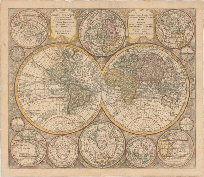
“Diversi Globi Terr-Aquei Statione Variante et Visu Intercedente, per Coluros Tropicorum, per Ambos Polos et Particul. Sphaerae Zenith in Planum Delineati Orthographici Prospectus...”
Map Maker:
Matthaus Seutter
This is one of the most graphic 18th century world... (full text available to subscribers)
| Item Detail |
| |
| |
MapMaker: |
Matthaus Seutter
|
|
| |
| |
Subject: |
World |
|
| |
Period/Size: |
1742 / 19.8" x 22.9" (50.3 x 58.2 cm)
|
|
| |
Color: |
Colored
|
|
| |
Condition: |
(B+) Original color that has been lightly refreshed with minor soiling and several short, professionally repaired centerfold separations. A previous extraneous fold along the equator has been pressed flat and archivally reinforced on verso. (condition help) |
|
| |
Source: |
Atlas Novus |
|
| |
References: |
Portinaro & Knirsch #119; Shirley (BL Atlases) T.SEU-2a #3. |
|
| |
|
|
| Sales Information |
| |
| |
Price: |
|
|
| |
| |
Offered by: |
Old World Auctions |
|
| |
Catalog: |
Auction No. 152 - Antique Maps, Charts, Atlases & Globes (9261) |
|
| |
Lot/Item #: |
21 |
|
| |
| |
Date: |
02/2015
|
|
| |
| |
|
Antique Maps - Valuation and Pricing, Descriptions, Resources |
|
Home |
Information |
Search |
Register |
Contact Us |
Site Map
Americana Exchange, Inc. © 1999 - 2024 Americana Exchange, Inc.. All rights reserved.
OldMaps.com, the OldMaps.com logo and
AMPR are service marks or registered service marks of Americana Exchange, Inc..
|