Title:
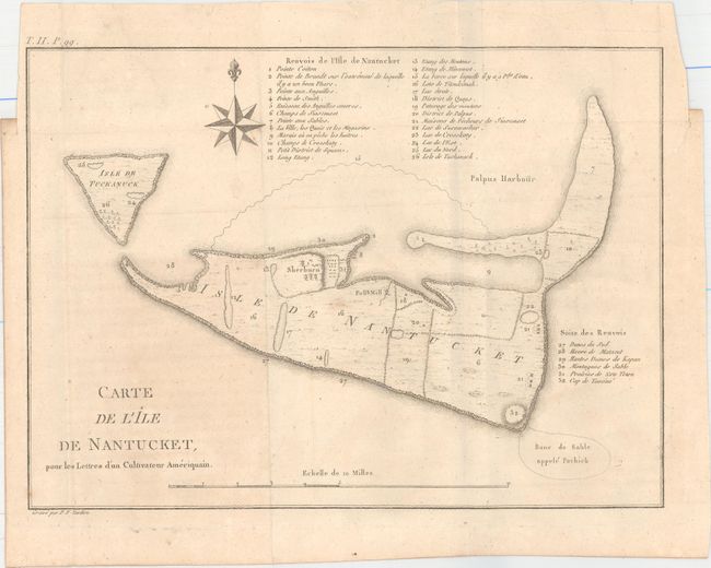
“Carte de l'Ile de Nantucket, pour les Lettres d’un Cultivateur Ameriquain”
Map Maker:
Michel Guillaume St. Jean de Crevecoeur
This early copper engraved map of Nantucket includ... (full text available to subscribers)
| Item Detail |
| |
| |
MapMaker: |
Michel Guillaume St. Jean de Crevecoeur
|
|
| |
| |
Subject: |
Nantucket, Massachusetts |
|
| |
Period/Size: |
1787 / 8.0" x 11.0" (20.4 x 28.0 cm)
|
|
| |
Color: |
Black & White
|
|
| |
Condition: |
(B+) Faint offsetting and a few minor spots with a short binding tear confined to the right blank margin. Issued folding. (condition help) |
|
| |
Source: |
Lettres d'un Cultivateur Ameriqain |
|
| |
References: |
Phillips (M) p. 457; Howes #C883. |
|
| |
|
|
| Sales Information |
| |
| |
Price: |
|
|
| |
| |
Offered by: |
Old World Auctions |
|
| |
Catalog: |
Auction No. 152 - Antique Maps, Charts, Atlases & Globes (9261) |
|
| |
Lot/Item #: |
221 |
|
| |
| |
Date: |
02/2015
|
|
| |
| |
|
Antique Maps - Valuation and Pricing, Descriptions, Resources |
|
Home |
Information |
Search |
Register |
Contact Us |
Site Map
Americana Exchange, Inc. © 1999 - 2024 Americana Exchange, Inc.. All rights reserved.
OldMaps.com, the OldMaps.com logo and
AMPR are service marks or registered service marks of Americana Exchange, Inc..
|