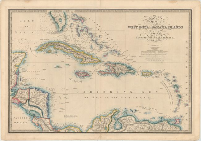
Title:
“Map of the West India & Bahama Islands with the Adjacent Coasts of Yucatan, Honduras, Caracas &c.”
Map Maker:
James Wyld
This elegantly engraved, large-scale map covers al... (full text available to subscribers)
| Item Detail |
| |
| |
MapMaker: |
James Wyld
|
|
| |
| |
Subject: |
Caribbean |
|
| |
Period/Size: |
1847 / 20.7" x 30.7" (52.6 x 78.0 cm)
|
|
| |
Color: |
Colored
|
|
| |
Condition: |
(B+) Nice impression and color with minor soiling and archivally repaired centerfold separations that just enter map border at bottom and enter 1" into map at top. A tear confined to top blank margin has also been archivally repaired. (condition help) |
|
| |
Source: |
|
|
| |
References: |
|
|
| |
|
|
| Sales Information |
| |
| |
Price: |
|
|
| |
| |
Offered by: |
Old World Auctions |
|
| |
Catalog: |
Auction No. 152 - Antique Maps, Charts, Atlases & Globes (9261) |
|
| |
Lot/Item #: |
320 |
|
| |
| |
Date: |
02/2015
|
|
| |
| |
|
Antique Maps - Valuation and Pricing, Descriptions, Resources |
|
Home |
Information |
Search |
Register |
Contact Us |
Site Map
Americana Exchange, Inc. © 1999 - 2024 Americana Exchange, Inc.. All rights reserved.
OldMaps.com, the OldMaps.com logo and
AMPR are service marks or registered service marks of Americana Exchange, Inc..
|