Title:
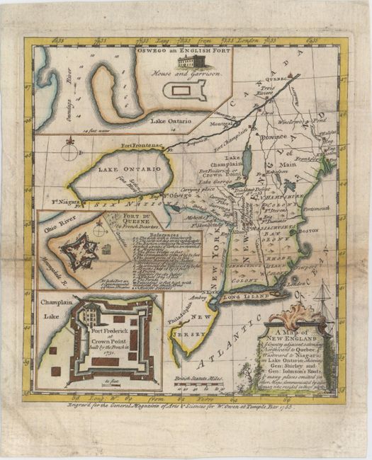
“A Map of New England & ye Country Adjacent, Extending Northward to Quebec & Westward to Niagara, on Lake Ontairo, Shewing Gen: Shirley and Gen: Johnson's Routs, & Many Places Omitted in Other Maps; Communicated by a Gentleman Who Resided in These Parts”
Map Maker:
Anonymous
This uncommon map of New England covers the area f... (full text available to subscribers)
| Item Detail |
| |
| |
MapMaker: |
Anonymous
|
|
| |
| |
Subject: |
Colonial New England |
|
| |
Period/Size: |
1755 / 8.0" x 7.0" (20.4 x 17.8 cm)
|
|
| |
Color: |
Colored
|
|
| |
Condition: |
(B) Issued folding, now pressed with a long separation along one fold that has been closed on verso. There is light toning along the fold, a few minor extraneous creases, and light soiling. (condition help) |
|
| |
Source: |
General Magazine of Arts & Scinece |
|
| |
References: |
Jolly #GEN-MAS-70; McCorkle #755-27; Sellers & Van Ee #64. |
|
| |
|
|
| Sales Information |
| |
| |
Price: |
|
|
| |
| |
Offered by: |
Old World Auctions |
|
| |
Catalog: |
Auction No. 152 - Antique Maps, Charts, Atlases & Globes (9261) |
|
| |
Lot/Item #: |
151 |
|
| |
| |
Date: |
02/2015
|
|
| |
| |
|
Antique Maps - Valuation and Pricing, Descriptions, Resources |
|
Home |
Information |
Search |
Register |
Contact Us |
Site Map
Americana Exchange, Inc. © 1999 - 2024 Americana Exchange, Inc.. All rights reserved.
OldMaps.com, the OldMaps.com logo and
AMPR are service marks or registered service marks of Americana Exchange, Inc..
|