Title:
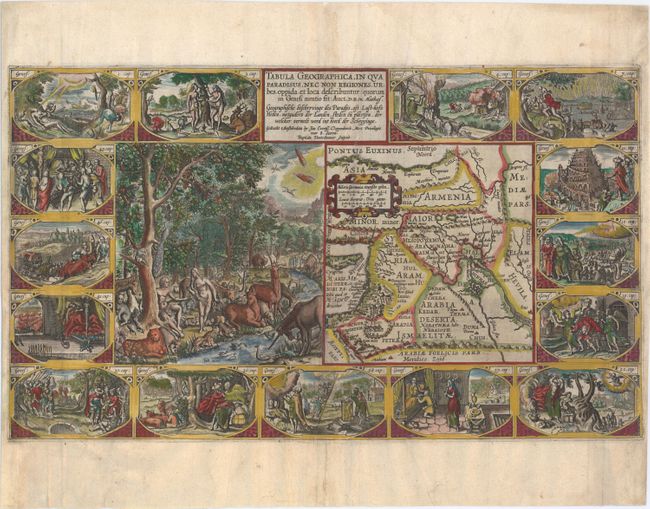
“Tabula Geographica, in qua Paradisus, nec non Regiones, Urbes, Oppida, et Loca Describuntur...”
Map Maker:
Plancius/Cloppenburg
This supremely graphic map is from the second seri... (full text available to subscribers)
| Item Detail |
| |
| |
MapMaker: |
Plancius/Cloppenburg
|
|
| |
| |
Subject: |
Middle East |
|
| |
Period/Size: |
1625 / 11.4" x 19.6" (29.0 x 49.8 cm)
|
|
| |
Color: |
Colored
|
|
| |
Condition: |
(B) A strong impression with attractive color, issued folding and now pressed flat. There are professionally repairs to two tiny worm tracks in the image at bottom center, and a printer's crease along the centerfold has been pressed flat with a minor amo (condition help) |
|
| |
Source: |
|
|
| |
References: |
Laor #565; Poortman & Augusteijn #73. |
|
| |
|
|
| Sales Information |
| |
| |
Price: |
|
|
| |
| |
Offered by: |
Old World Auctions |
|
| |
Catalog: |
Auction No. 152 - Antique Maps, Charts, Atlases & Globes (9261) |
|
| |
Lot/Item #: |
566 |
|
| |
| |
Date: |
02/2015
|
|
| |
| |
|
Antique Maps - Valuation and Pricing, Descriptions, Resources |
|
Home |
Information |
Search |
Register |
Contact Us |
Site Map
Americana Exchange, Inc. © 1999 - 2024 Americana Exchange, Inc.. All rights reserved.
OldMaps.com, the OldMaps.com logo and
AMPR are service marks or registered service marks of Americana Exchange, Inc..
|