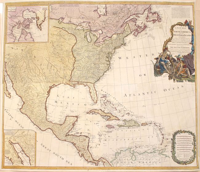
Title:
“A New Map of North America; with the West India Islands. Divided According to the Preliminary Articles of Peace, Signed at Versailles, 20, Jan. 1783”
Map Maker:
Laurie & Whittle
This large, influential map had a long and varied ... (full text available to subscribers)
| Item Detail |
| |
| |
MapMaker: |
Laurie & Whittle
|
|
| |
| |
Subject: |
North America |
|
| |
Period/Size: |
1794 / 39.5" x 45.7" (100.4 x 116.1 cm)
|
|
| |
Color: |
Colored
|
|
| |
Condition: |
(B+) Attractive color on watermarked paper with very faint offsetting in some of the blank areas of the map. Professionally backed with tissue to reinforce and repair a thin, 3.5" crack to the left of the title cartouche and a 1.25" tear in central Mexic (condition help) |
|
| |
Source: |
|
|
| |
References: |
Phillips (Maps) p. 865. |
|
| |
|
|
| Sales Information |
| |
| |
Price: |
|
|
| |
| |
Offered by: |
Old World Auctions |
|
| |
Catalog: |
Auction No. 155 - Antique Maps, Charts, Atlases & Globes (9278) |
|
| |
Lot/Item #: |
84 |
|
| |
| |
Date: |
11/2015
|
|
| |
| |
|
Antique Maps - Valuation and Pricing, Descriptions, Resources |
|
Home |
Information |
Search |
Register |
Contact Us |
Site Map
Americana Exchange, Inc. © 1999 - 2024 Americana Exchange, Inc.. All rights reserved.
OldMaps.com, the OldMaps.com logo and
AMPR are service marks or registered service marks of Americana Exchange, Inc..
|