Title:
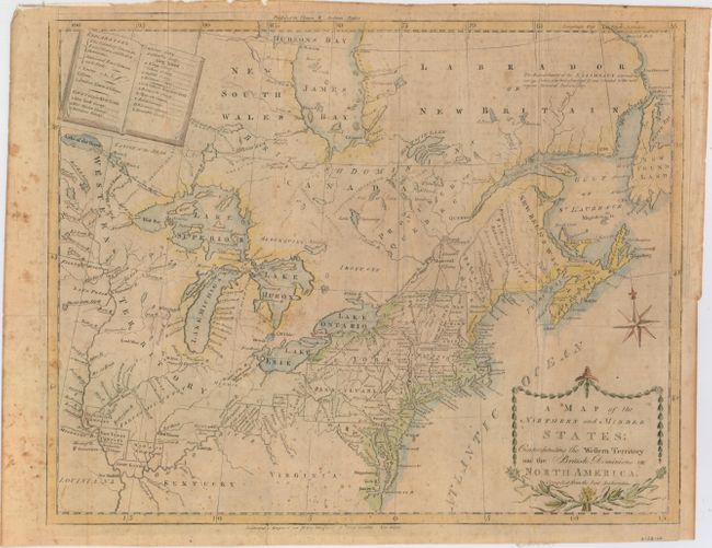
“A Map of the Northern and Middle States: Comprehending the Western Territory and the British Dominions in North America, Compiled from the Best Authorities”
Map Maker:
Amos Doolittle
This uncommon and information-packed map describes... (full text available to subscribers)
| Item Detail |
| |
| |
MapMaker: |
Amos Doolittle
|
|
| |
| |
Subject: |
Northeastern United States & Canada |
|
| |
Period/Size: |
1793 / 12.5" x 16.0" (31.8 x 40.7 cm)
|
|
| |
Color: |
Colored
|
|
| |
Condition: |
(B) Issued folding and now pressed with archival repairs to several short fold separations and tiny holes at fold intersections. There is scattered foxing and a 1.5" edge tear at top that has been closed on verso with archival material. Binding trim at (condition help) |
|
| |
Source: |
Morse's American Universal Geography |
|
| |
References: |
McCorkle #789.6; Kershaw #386; Sellers & Van Ee #194; Wheat & Brun #153. |
|
| |
|
|
| Sales Information |
| |
| |
Price: |
|
|
| |
| |
Offered by: |
Old World Auctions |
|
| |
Catalog: |
Auction No. 153 - Antique Maps, Charts, Atlases & Globes (9276) |
|
| |
Lot/Item #: |
126 |
|
| |
| |
Date: |
05/2015
|
|
| |
| |
|
Antique Maps - Valuation and Pricing, Descriptions, Resources |
|
Home |
Information |
Search |
Register |
Contact Us |
Site Map
Americana Exchange, Inc. © 1999 - 2024 Americana Exchange, Inc.. All rights reserved.
OldMaps.com, the OldMaps.com logo and
AMPR are service marks or registered service marks of Americana Exchange, Inc..
|