Title:
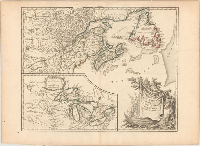
“Partie de l'Amerique Septent? qui Comprend la Nouvelle France ou le Canada”
Map Maker:
Didier Robert de Vaugondy
This is a handsome map of Newfoundland, Nova Scoti... (full text available to subscribers)
| Item Detail |
| |
| |
MapMaker: |
Didier Robert de Vaugondy
|
|
| |
| |
Subject: |
Northeastern United States & Canada, Great Lakes |
|
| |
Period/Size: |
1799 / 19.1" x 23.8" (48.6 x 60.5 cm)
|
|
| |
Color: |
Colored
|
|
| |
Condition: |
(A) A nice impression and original outline color on a watermarked sheet with minor offsetting and a few faint spots. (condition help) |
|
| |
Source: |
Atlas Universel |
|
| |
References: |
Pedley #459; Karpinski p.141-42; Kershaw #357; McCorkle #755.36. |
|
| |
|
|
| Sales Information |
| |
| |
Price: |
|
|
| |
| |
Offered by: |
Old World Auctions |
|
| |
Catalog: |
Auction No. 153 - Antique Maps, Charts, Atlases & Globes (9276) |
|
| |
Lot/Item #: |
128 |
|
| |
| |
Date: |
05/2015
|
|
| |
| |
|
Antique Maps - Valuation and Pricing, Descriptions, Resources |
|
Home |
Information |
Search |
Register |
Contact Us |
Site Map
Americana Exchange, Inc. © 1999 - 2024 Americana Exchange, Inc.. All rights reserved.
OldMaps.com, the OldMaps.com logo and
AMPR are service marks or registered service marks of Americana Exchange, Inc..
|