Title:
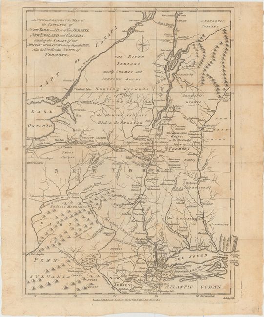
“A New and Accurate Map of the Province of New York and Part of the Jerseys, New England and Canada, Shewing the Scenes of Our Military Operations During the Present War. Also the New Erected State of Vermont.”
Map Maker:
John Lodge
A detailed and interesting map of the field of mil... (full text available to subscribers)
| Item Detail |
| |
| |
MapMaker: |
John Lodge
|
|
| |
| |
Subject: |
Colonial New England & Mid-Atlantic United States |
|
| |
Period/Size: |
1780 / 14.5" x 10.8" (36.9 x 27.5 cm)
|
|
| |
Color: |
Black & White
|
|
| |
Condition: |
(B) Issued folding on watermarked paper with light toning and offsetting and several faint spots. There are light extraneous creases in the corners of the map where it was misfolded into the magazine. (condition help) |
|
| |
Source: |
Political Magazine |
|
| |
References: |
Jolly #POL-14; Sellers & van Ee #176; McCorkle #780-9. |
|
| |
|
|
| Sales Information |
| |
| |
Price: |
|
|
| |
| |
Offered by: |
Old World Auctions |
|
| |
Catalog: |
Auction No. 153 - Antique Maps, Charts, Atlases & Globes (9276) |
|
| |
Lot/Item #: |
158 |
|
| |
| |
Date: |
05/2015
|
|
| |
| |
|
Antique Maps - Valuation and Pricing, Descriptions, Resources |
|
Home |
Information |
Search |
Register |
Contact Us |
Site Map
Americana Exchange, Inc. © 1999 - 2024 Americana Exchange, Inc.. All rights reserved.
OldMaps.com, the OldMaps.com logo and
AMPR are service marks or registered service marks of Americana Exchange, Inc..
|