Title:
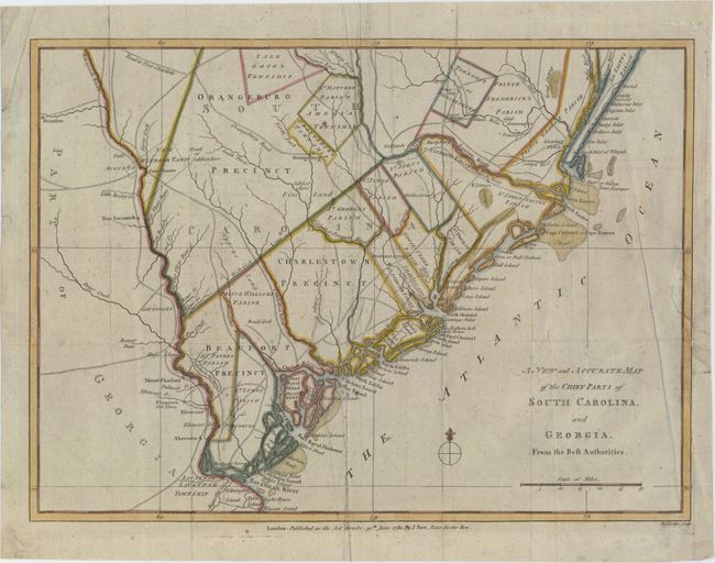
“A New and Accurate Map of the Chief Parts of South Carolina, and Georgia, from the Best Authorities”
Map Maker:
John Lodge
Scarce Revolutionary War map of the region ... (full text available to subscribers)
| Item Detail |
| |
| |
MapMaker: |
John Lodge
|
|
| |
| |
Subject: |
Colonial Southeast United States |
|
| |
Period/Size: |
1780 / 10.8" x 14.8" (27.5 x 37.6 cm)
|
|
| |
Color: |
Colored
|
|
| |
Condition: |
(B+) A nice impression with attractive color on watermarked paper. There is light scattered foxing and soiling. Issued folding with a binding trim that has been replaced with old paper and an adjacent binding tear that enters 2" into map and has been re (condition help) |
|
| |
Source: |
Political Magazine |
|
| |
References: |
Jolly #POL-7. |
|
| |
|
|
| Sales Information |
| |
| |
Price: |
|
|
| |
| |
Offered by: |
Old World Auctions |
|
| |
Catalog: |
Auction No. 153 - Antique Maps, Charts, Atlases & Globes (9276) |
|
| |
Lot/Item #: |
181 |
|
| |
| |
Date: |
05/2015
|
|
| |
| |
|
Antique Maps - Valuation and Pricing, Descriptions, Resources |
|
Home |
Information |
Search |
Register |
Contact Us |
Site Map
Americana Exchange, Inc. © 1999 - 2024 Americana Exchange, Inc.. All rights reserved.
OldMaps.com, the OldMaps.com logo and
AMPR are service marks or registered service marks of Americana Exchange, Inc..
|