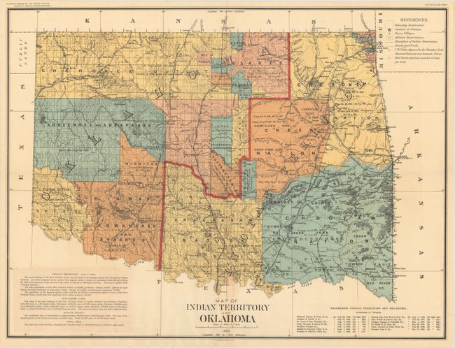
Title:
“Map of Indian Territory and Oklahoma”
Map Maker:
U.S. Government
Large, colorful, and historically significant map ... (full text available to subscribers)
| Item Detail |
| |
| |
MapMaker: |
U.S. Government
|
|
| |
| |
Subject: |
Oklahoma |
|
| |
Period/Size: |
1890 / 22.0" x 29.5" (55.9 x 75.0 cm)
|
|
| |
Color: |
Colored
|
|
| |
Condition: |
(A) A clean, bright example with a small amount of toning along the centerfold at bottom. Issued folding with a few tiny splits at fold intersections. (condition help) |
|
| |
Source: |
11th Census, Report of Indians Taxed and Indians Not Taxed |
|
| |
References: |
|
|
| |
|
|
| Sales Information |
| |
| |
Price: |
|
|
| |
| |
Offered by: |
Old World Auctions |
|
| |
Catalog: |
Auction No. 153 - Antique Maps, Charts, Atlases & Globes (9276) |
|
| |
Lot/Item #: |
305 |
|
| |
| |
Date: |
05/2015
|
|
| |
| |
|
Antique Maps - Valuation and Pricing, Descriptions, Resources |
|
Home |
Information |
Search |
Register |
Contact Us |
Site Map
Americana Exchange, Inc. © 1999 - 2024 Americana Exchange, Inc.. All rights reserved.
OldMaps.com, the OldMaps.com logo and
AMPR are service marks or registered service marks of Americana Exchange, Inc..
|