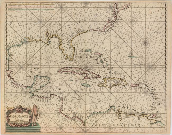
Title:
“Pascaerte vande Caribische Eylanden, vande Barbados tot Aende Bocht van Mexico”
Map Maker:
Henrick Doncker
This is the rare first state of Doncker's chart of... (full text available to subscribers)
| Item Detail |
| |
| |
MapMaker: |
Henrick Doncker
|
|
| |
| |
Subject: |
Gulf of Mexico & Caribbean |
|
| |
Period/Size: |
1659 / 17.2" x 21.5" (43.7 x 54.7 cm)
|
|
| |
Color: |
Colored
|
|
| |
Condition: |
(A) A strong impression with a couple of very faint spots and several professional repairs to minor chips and tears in blank margins. (condition help) |
|
| |
Source: |
De Zee-Atlas oft Water-Waereld |
|
| |
References: |
Burden #339. |
|
| |
|
|
| Sales Information |
| |
| |
Price: |
|
|
| |
| |
Offered by: |
Old World Auctions |
|
| |
Catalog: |
Auction No. 153 - Antique Maps, Charts, Atlases & Globes (9276) |
|
| |
Lot/Item #: |
372 |
|
| |
| |
Date: |
05/2015
|
|
| |
| |
|
Antique Maps - Valuation and Pricing, Descriptions, Resources |
|
Home |
Information |
Search |
Register |
Contact Us |
Site Map
Americana Exchange, Inc. © 1999 - 2024 Americana Exchange, Inc.. All rights reserved.
OldMaps.com, the OldMaps.com logo and
AMPR are service marks or registered service marks of Americana Exchange, Inc..
|