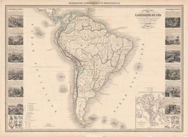
Title:
“Nouvelle Carte Illustre de l'Amerique du Sud Indiquant les Grandes Divisions Physiques, la Distribution Geographique des Vegetaux et des Mineraux...”
Map Maker:
Alexander A. Vuillemin
This magnificent large chart is from this scarce n... (full text available to subscribers)
| Item Detail |
| |
| |
MapMaker: |
Alexander A. Vuillemin
|
|
| |
| |
Subject: |
South America |
|
| |
Period/Size: |
1860 / 23.6" x 33.2" (60.0 x 84.4 cm)
|
|
| |
Color: |
Colored
|
|
| |
Condition: |
(B+) Original outline color with short, archivally repaired centerfold separations at top and bottom. There are a couple of light spots in the map and some damp stains in the blank margins, but it is overall very clean and attractive. There are some tin (condition help) |
|
| |
Source: |
Geographie Commerciale et Industrielle |
|
| |
References: |
|
|
| |
|
|
| Sales Information |
| |
| |
Price: |
|
|
| |
| |
Offered by: |
Old World Auctions |
|
| |
Catalog: |
Auction No. 153 - Antique Maps, Charts, Atlases & Globes (9276) |
|
| |
Lot/Item #: |
403 |
|
| |
| |
Date: |
05/2015
|
|
| |
| |
|
Antique Maps - Valuation and Pricing, Descriptions, Resources |
|
Home |
Information |
Search |
Register |
Contact Us |
Site Map
Americana Exchange, Inc. © 1999 - 2024 Americana Exchange, Inc.. All rights reserved.
OldMaps.com, the OldMaps.com logo and
AMPR are service marks or registered service marks of Americana Exchange, Inc..
|