Title:
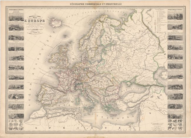
“Nouvelle Carte Illustre de l'Europe Presentant les Grandes Divisions Physiques, la Distribution Geographique des Vegetaux et des Mineraux...”
Map Maker:
Alexander A. Vuillemin
A handsome, large chart from this scarce nineteent... (full text available to subscribers)
| Item Detail |
| |
| |
MapMaker: |
Alexander A. Vuillemin
|
|
| |
| |
Subject: |
Europe |
|
| |
Period/Size: |
1861 / 23.6" x 33.3" (60.0 x 84.6 cm)
|
|
| |
Color: |
Colored
|
|
| |
Condition: |
(B+) Original color on a sound sheet with minor foxing along the centerfold at bottom and small damps stains at the top and bottom of the sheet, also along the centerfold. Lower margin reinforced with tissue. There are some tiny tears along the edges o (condition help) |
|
| |
Source: |
Geographie Commerciale et Industrielle |
|
| |
References: |
|
|
| |
|
|
| Sales Information |
| |
| |
Price: |
|
|
| |
| |
Offered by: |
Old World Auctions |
|
| |
Catalog: |
Auction No. 153 - Antique Maps, Charts, Atlases & Globes (9276) |
|
| |
Lot/Item #: |
441 |
|
| |
| |
Date: |
05/2015
|
|
| |
| |
|
Antique Maps - Valuation and Pricing, Descriptions, Resources |
|
Home |
Information |
Search |
Register |
Contact Us |
Site Map
Americana Exchange, Inc. © 1999 - 2024 Americana Exchange, Inc.. All rights reserved.
OldMaps.com, the OldMaps.com logo and
AMPR are service marks or registered service marks of Americana Exchange, Inc..
|