Title:
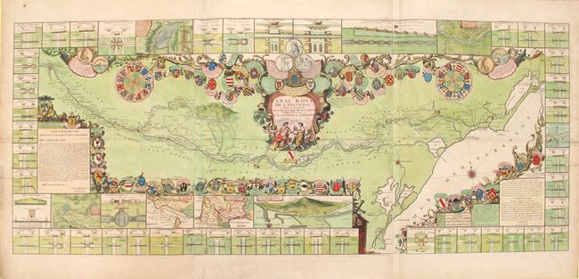
“Le Canal Royal de Languedoc, pour la Ionction de l'Ocean et de la Mer Mediterranee Dedie et Presente a Mgrs. des Estats de Languedoc”
Map Maker:
Jean Batiste Nolin
This impressive map on three joined sheets depicts... (full text available to subscribers)
| Item Detail |
| |
| |
MapMaker: |
Jean Batiste Nolin
|
|
| |
| |
Subject: |
Southern France |
|
| |
Period/Size: |
1697 / 23.3" x 56.8" (59.2 x 144.3 cm)
|
|
| |
Color: |
Colored
|
|
| |
Condition: |
(B+) A nice impression with superb color and good margins. There are two 2" tears that enter the image at left and have been closed on verso with old paper, as well as a number of short tears confined to the blank margins that have been archivally repair (condition help) |
|
| |
Source: |
|
|
| |
References: |
|
|
| |
|
|
| Sales Information |
| |
| |
Price: |
|
|
| |
| |
Offered by: |
Old World Auctions |
|
| |
Catalog: |
Auction No. 153 - Antique Maps, Charts, Atlases & Globes (9276) |
|
| |
Lot/Item #: |
495 |
|
| |
| |
Date: |
05/2015
|
|
| |
| |
|
Antique Maps - Valuation and Pricing, Descriptions, Resources |
|
Home |
Information |
Search |
Register |
Contact Us |
Site Map
Americana Exchange, Inc. © 1999 - 2024 Americana Exchange, Inc.. All rights reserved.
OldMaps.com, the OldMaps.com logo and
AMPR are service marks or registered service marks of Americana Exchange, Inc..
|