Title:
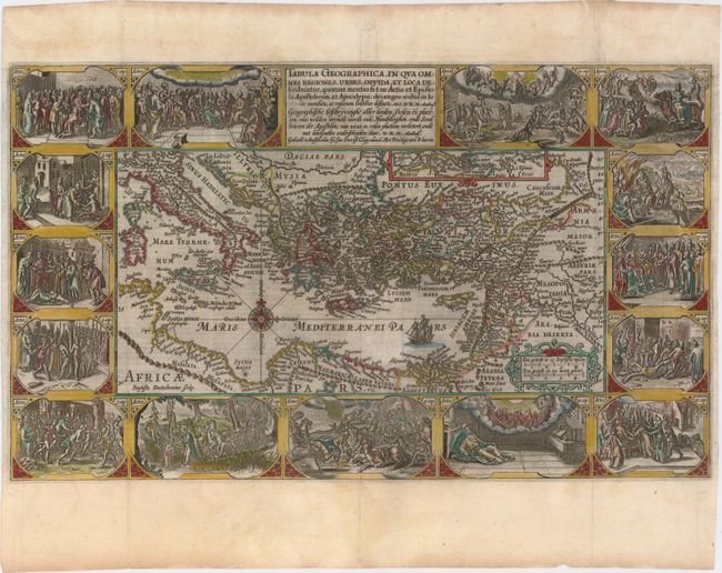
“Tabula Geographica, in Qua Omnes Regiones, Urbes, Oppida, et Loca Describuntur, quorum mentio sit in Actis et Epistolis Apostolorum, et Apaocalypsi…”
Map Maker:
Plancius/Cloppenburg
This superb, graphic map of the eastern Mediterran... (full text available to subscribers)
| Item Detail |
| |
| |
MapMaker: |
Plancius/Cloppenburg
|
|
| |
| |
Subject: |
Eastern Mediterranean & Middle East |
|
| |
Period/Size: |
1643 / 11.3" x 19.3" (28.7 x 49.1 cm)
|
|
| |
Color: |
Colored
|
|
| |
Condition: |
(A) A dark impression on watermarked paper with attractive color and several very minor printer's creases adjacent to the centerfold. There is a professionally repaired tear that extends 1" into the vignette at top right. Narrow side margins, as issued. (condition help) |
|
| |
Source: |
|
|
| |
References: |
Poortman & Augusteijn #82; Laor #570. |
|
| |
|
|
| Sales Information |
| |
| |
Price: |
|
|
| |
| |
Offered by: |
Old World Auctions |
|
| |
Catalog: |
Auction No. 153 - Antique Maps, Charts, Atlases & Globes (9276) |
|
| |
Lot/Item #: |
598 |
|
| |
| |
Date: |
05/2015
|
|
| |
| |
|
Antique Maps - Valuation and Pricing, Descriptions, Resources |
|
Home |
Information |
Search |
Register |
Contact Us |
Site Map
Americana Exchange, Inc. © 1999 - 2024 Americana Exchange, Inc.. All rights reserved.
OldMaps.com, the OldMaps.com logo and
AMPR are service marks or registered service marks of Americana Exchange, Inc..
|