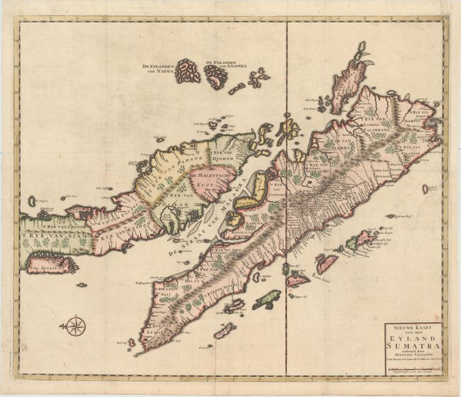
Title:
“Nieuwe Kaart van het Eyland Sumatra”
Map Maker:
Francois Valentijn
This finely engraved copper-plate chart shows all ... (full text available to subscribers)
| Item Detail |
| |
| |
MapMaker: |
Francois Valentijn
|
|
| |
| |
Subject: |
Sumatra & the Malaysian Peninsula |
|
| |
Period/Size: |
1726 / 20.1" x 23.8" (51.1 x 60.5 cm)
|
|
| |
Color: |
Colored
|
|
| |
Condition: |
(B+) A crisp impression with attractive color and a couple of minor spots. Issued folding with a binding trim at top right that has been replaced with old paper and an adjacent binding tear that enters 3" into map and has been professionally repaired. (condition help) |
|
| |
Source: |
Oud en Nieuw Oost-Indien |
|
| |
References: |
Shirley (BL Atlases) G.VALN-1a #49. |
|
| |
|
|
| Sales Information |
| |
| |
Price: |
|
|
| |
| |
Offered by: |
Old World Auctions |
|
| |
Catalog: |
Auction No. 153 - Antique Maps, Charts, Atlases & Globes (9276) |
|
| |
Lot/Item #: |
675 |
|
| |
| |
Date: |
05/2015
|
|
| |
| |
|
Antique Maps - Valuation and Pricing, Descriptions, Resources |
|
Home |
Information |
Search |
Register |
Contact Us |
Site Map
Americana Exchange, Inc. © 1999 - 2024 Americana Exchange, Inc.. All rights reserved.
OldMaps.com, the OldMaps.com logo and
AMPR are service marks or registered service marks of Americana Exchange, Inc..
|