Title:
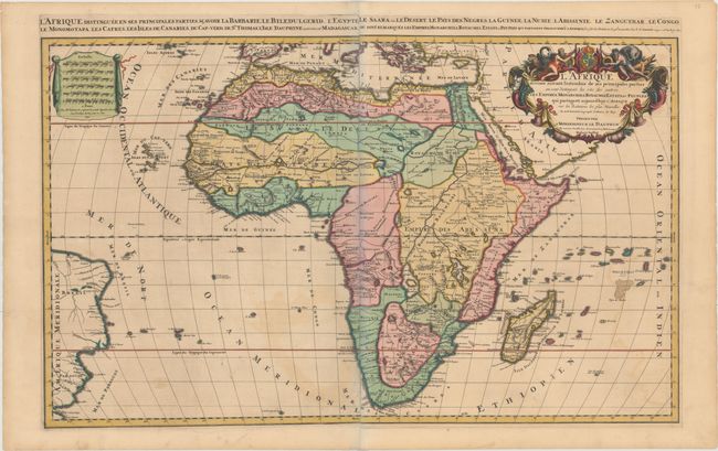
“L'Afrique Divisee Suivant l'Estendue de Ses Principales Parties ou sont Distingues les uns des Autres les Empires, Monarchies, Royaumes, Estats, et Peuples...”
Map Maker:
Jaillot/Mortier
This striking map is the Mortier version of Jaillo... (full text available to subscribers)
| Item Detail |
| |
| |
MapMaker: |
Jaillot/Mortier
|
|
| |
| |
Subject: |
Africa |
|
| |
Period/Size: |
1692 / 21.1" x 34.4" (53.6 x 87.4 cm)
|
|
| |
Color: |
Colored
|
|
| |
Condition: |
(B+) A crisp impression with lovely original color, light toning, and light offsetting. The slight bluish shadow along the joint in the image is a product of the scanning process and is not present on the actual map. (condition help) |
|
| |
Source: |
Atlas Nouveau |
|
| |
References: |
Betz #156.1; Norwich #46; Pastoureau, JAILLOT I D [4]; Tooley (MCC-47) p. 46, plt. #16. |
|
| |
|
|
| Sales Information |
| |
| |
Price: |
|
|
| |
| |
Offered by: |
Old World Auctions |
|
| |
Catalog: |
Auction No. 153 - Antique Maps, Charts, Atlases & Globes (9276) |
|
| |
Lot/Item #: |
694 |
|
| |
| |
Date: |
05/2015
|
|
| |
| |
|
Antique Maps - Valuation and Pricing, Descriptions, Resources |
|
Home |
Information |
Search |
Register |
Contact Us |
Site Map
Americana Exchange, Inc. © 1999 - 2024 Americana Exchange, Inc.. All rights reserved.
OldMaps.com, the OldMaps.com logo and
AMPR are service marks or registered service marks of Americana Exchange, Inc..
|