Title:
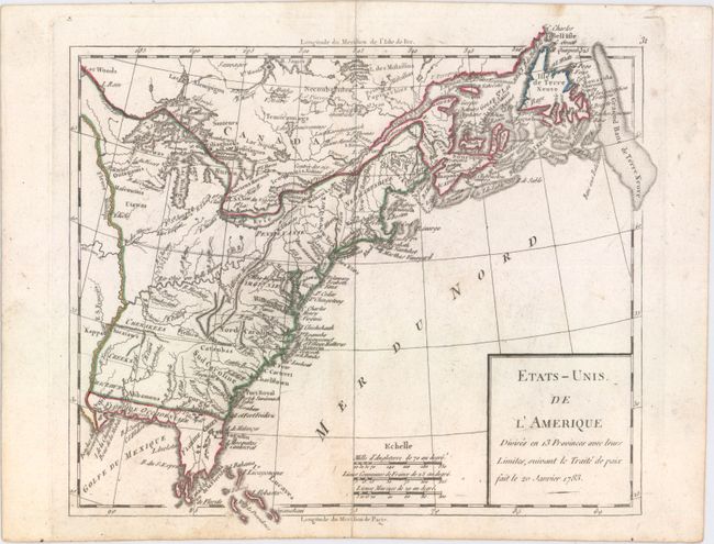
“Etats-Unis de l'Amerique Divises en 13 Provinces avec Leurs Limites, Suivant le Traite de Paix fait le 20 Janvier 1783”
Map Maker:
Robert de Vaugondy [Family]
This is an early map of the newly created United S... (full text available to subscribers)
| Item Detail |
| |
| |
MapMaker: |
Robert de Vaugondy [Family]
|
|
| |
| |
Subject: |
Eastern United States & Canada |
|
| |
Period/Size: |
1791 / 8.1" x 9.3" (20.6 x 23.7 cm)
|
|
| |
Color: |
Colored
|
|
| |
Condition: |
(A) Original outline color with minor soiling and a short centerfold separation at bottom. (condition help) |
|
| |
Source: |
|
|
| |
References: |
cf. McCorkle #783.12. |
|
| |
|
|
| Sales Information |
| |
| |
Price: |
|
|
| |
| |
Offered by: |
Old World Auctions |
|
| |
Catalog: |
Auction No. 154 - Antique Maps, Charts, Atlases & Globes (9277) |
|
| |
Lot/Item #: |
102 |
|
| |
| |
Date: |
09/2015
|
|
| |
| |
|
Antique Maps - Valuation and Pricing, Descriptions, Resources |
|
Home |
Information |
Search |
Register |
Contact Us |
Site Map
Americana Exchange, Inc. © 1999 - 2024 Americana Exchange, Inc.. All rights reserved.
OldMaps.com, the OldMaps.com logo and
AMPR are service marks or registered service marks of Americana Exchange, Inc..
|