Title:
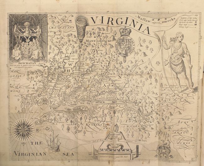
“The True Travels, Adventures and Observations of Captaine John Smith, in Europe, Asia, Africke, and America…”
Map Maker:
John Smith
This is the first American edition of Smith's hist... (full text available to subscribers)
| Item Detail |
| |
| |
MapMaker: |
John Smith
|
|
| |
| |
Subject: |
Mid-Atlantic United States |
|
| |
Period/Size: |
1819 / 8.7" x 5.3" (22.1 x 13.5 cm)
|
|
| |
Color: |
Black & White
|
|
| |
Condition: |
(B) Overall the text, folding plates and folding map have light scattered foxing. The map has a 2" binding tear professionally repaired on verso with archival material. The plate containing native scenes has a 10" edge tear that has been professionally (condition help) |
|
| |
Source: |
|
|
| |
References: |
Verner (MCC-45) p. 28; cf. Burden #164. |
|
| |
|
|
| Sales Information |
| |
| |
Price: |
|
|
| |
| |
Offered by: |
Old World Auctions |
|
| |
Catalog: |
Auction No. 154 - Antique Maps, Charts, Atlases & Globes (9277) |
|
| |
Lot/Item #: |
149 |
|
| |
| |
Date: |
09/2015
|
|
| |
| |
|
Antique Maps - Valuation and Pricing, Descriptions, Resources |
|
Home |
Information |
Search |
Register |
Contact Us |
Site Map
Americana Exchange, Inc. © 1999 - 2024 Americana Exchange, Inc.. All rights reserved.
OldMaps.com, the OldMaps.com logo and
AMPR are service marks or registered service marks of Americana Exchange, Inc..
|