Title:
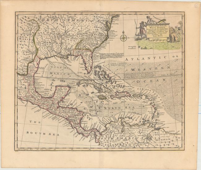
“An Accurate Map of the West Indies. Drawn from the Best Authorities, Assisted by the Most Approved Modern Maps and Charts, and Regulated by Astronomical Observations”
Map Maker:
Emanuel Bowen
This handsome map covers the southeastern United S... (full text available to subscribers)
| Item Detail |
| |
| |
MapMaker: |
Emanuel Bowen
|
|
| |
| |
Subject: |
Gulf of Mexico & Caribbean |
|
| |
Period/Size: |
1747 / 13.7" x 16.6" (34.8 x 42.2 cm)
|
|
| |
Color: |
Colored
|
|
| |
Condition: |
(A) A crisp impression with original outline color and later coloring in the cartouche. There are a couple of tiny holes only visible when held to light and faint overall toning. (condition help) |
|
| |
Source: |
A Complete System of Geography... |
|
| |
References: |
Sellers & Van Ee #1682; McCorkle (18th C. Geography Books) #17-38. |
|
| |
|
|
| Sales Information |
| |
| |
Price: |
|
|
| |
| |
Offered by: |
Old World Auctions |
|
| |
Catalog: |
Auction No. 154 - Antique Maps, Charts, Atlases & Globes (9277) |
|
| |
Lot/Item #: |
320 |
|
| |
| |
Date: |
09/2015
|
|
| |
| |
|
Antique Maps - Valuation and Pricing, Descriptions, Resources |
|
Home |
Information |
Search |
Register |
Contact Us |
Site Map
Americana Exchange, Inc. © 1999 - 2024 Americana Exchange, Inc.. All rights reserved.
OldMaps.com, the OldMaps.com logo and
AMPR are service marks or registered service marks of Americana Exchange, Inc..
|