Title:
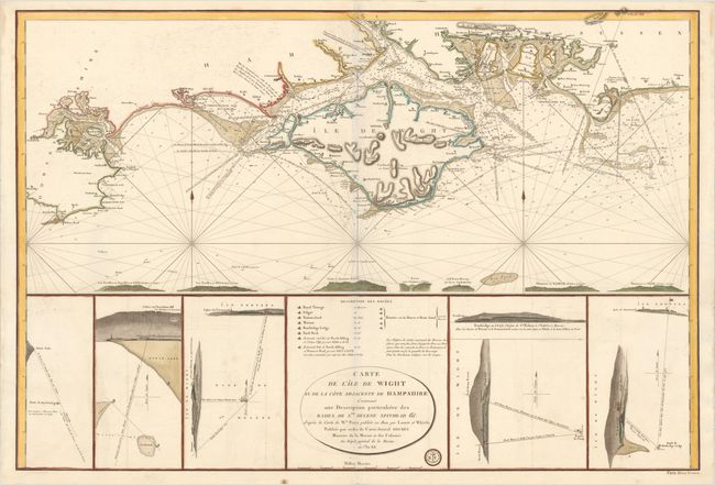
“Carte de l'Ile de Wight et de la Cote Adjacente de Hampshire Contenant une Description Particuliere des Rades de Ste. Helene Spithead &c...”
Map Maker:
Depot de la Marine
This uncommon large-scale chart depicts the Isle o... (full text available to subscribers)
| Item Detail |
| |
| |
MapMaker: |
Depot de la Marine
|
|
| |
| |
Subject: |
Isle of Wight |
|
| |
Period/Size: |
1803 / 24.4" x 35.8" (62.0 x 91.0 cm)
|
|
| |
Color: |
Colored
|
|
| |
Condition: |
(A) A bright sheet with wide margins and minor offsetting. This is a faint blue shadow along the centerfold that is caused by our scanner and does not appear on the map itself. (condition help) |
|
| |
Source: |
|
|
| |
References: |
|
|
| |
|
|
| Sales Information |
| |
| |
Price: |
|
|
| |
| |
Offered by: |
Old World Auctions |
|
| |
Catalog: |
Auction No. 154 - Antique Maps, Charts, Atlases & Globes (9277) |
|
| |
Lot/Item #: |
431 |
|
| |
| |
Date: |
09/2015
|
|
| |
| |
|
Antique Maps - Valuation and Pricing, Descriptions, Resources |
|
Home |
Information |
Search |
Register |
Contact Us |
Site Map
Americana Exchange, Inc. © 1999 - 2024 Americana Exchange, Inc.. All rights reserved.
OldMaps.com, the OldMaps.com logo and
AMPR are service marks or registered service marks of Americana Exchange, Inc..
|