Title:
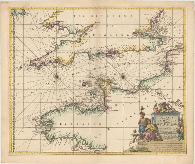
“Manica, Gallis la Manche, et Belgis het Canaal, Pars Oceani Inter Angliam et Galliam, Hujus Septentrionalem, & Illius Meridionalem...”
Map Maker:
Nicolas Visscher
This large-scale chart centers on the English Chan... (full text available to subscribers)
| Item Detail |
| |
| |
MapMaker: |
Nicolas Visscher
|
|
| |
| |
Subject: |
English Channel |
|
| |
Period/Size: |
1690 / 18.9" x 22.6" (48.0 x 57.4 cm)
|
|
| |
Color: |
Colored
|
|
| |
Condition: |
(A) An excellent impression with attractive color, minor creasing at top left, and a hint of toning along the centerfold. There are a few minute worm holes only visible when held to light. (condition help) |
|
| |
Source: |
|
|
| |
References: |
|
|
| |
|
|
| Sales Information |
| |
| |
Price: |
|
|
| |
| |
Offered by: |
Old World Auctions |
|
| |
Catalog: |
Auction No. 154 - Antique Maps, Charts, Atlases & Globes (9277) |
|
| |
Lot/Item #: |
452 |
|
| |
| |
Date: |
09/2015
|
|
| |
| |
|
Antique Maps - Valuation and Pricing, Descriptions, Resources |
|
Home |
Information |
Search |
Register |
Contact Us |
Site Map
Americana Exchange, Inc. © 1999 - 2024 Americana Exchange, Inc.. All rights reserved.
OldMaps.com, the OldMaps.com logo and
AMPR are service marks or registered service marks of Americana Exchange, Inc..
|