Title:
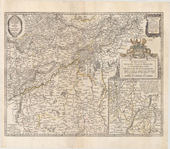
“De Hertochdommen Gulick Cleve Berghe en de Graefschappen vander Marck en Ravensbergh...”
Map Maker:
Blaeu [Family]
This rare map depicts present-day North Rhine-West... (full text available to subscribers)
| Item Detail |
| |
| |
MapMaker: |
Blaeu [Family]
|
|
| |
| |
Subject: |
Western Germany |
|
| |
Period/Size: |
1660 / 16.8" x 21.6" (42.7 x 54.9 cm)
|
|
| |
Color: |
Colored
|
|
| |
Condition: |
(B+) There is light soiling and a couple of archivally repaired edge tears at bottom. (condition help) |
|
| |
Source: |
|
|
| |
References: |
cf. Van der Krogt (Vol. II) #2381:2A. |
|
| |
|
|
| Sales Information |
| |
| |
Price: |
|
|
| |
| |
Offered by: |
Old World Auctions |
|
| |
Catalog: |
Auction No. 154 - Antique Maps, Charts, Atlases & Globes (9277) |
|
| |
Lot/Item #: |
516 |
|
| |
| |
Date: |
09/2015
|
|
| |
| |
|
Antique Maps - Valuation and Pricing, Descriptions, Resources |
|
Home |
Information |
Search |
Register |
Contact Us |
Site Map
Americana Exchange, Inc. © 1999 - 2024 Americana Exchange, Inc.. All rights reserved.
OldMaps.com, the OldMaps.com logo and
AMPR are service marks or registered service marks of Americana Exchange, Inc..
|