Title:
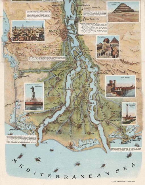
“The Nile from Alexandria to Aswan Illustrated Guide-Map Issued by the Tourist Development Association of Egypt”
Map Maker:
Lehnert & Landrock
This colorful and heavily illustrated map of the N... (full text available to subscribers)
| Item Detail |
| |
| |
MapMaker: |
Lehnert & Landrock
|
|
| |
| |
Subject: |
Egypt |
|
| |
Period/Size: |
1930 / 51.3" x 9.8" (130.3 x 24.9 cm)
|
|
| |
Color: |
Colored
|
|
| |
Condition: |
(B+) There are a few fold separations and edge tears that have been closed with tape on verso. The covers are lightly sunned and soiled. (condition help) |
|
| |
Source: |
|
|
| |
References: |
|
|
| |
|
|
| Sales Information |
| |
| |
Price: |
|
|
| |
| |
Offered by: |
Old World Auctions |
|
| |
Catalog: |
Auction No. 154 - Antique Maps, Charts, Atlases & Globes (9277) |
|
| |
Lot/Item #: |
712 |
|
| |
| |
Date: |
09/2015
|
|
| |
| |
|
Antique Maps - Valuation and Pricing, Descriptions, Resources |
|
Home |
Information |
Search |
Register |
Contact Us |
Site Map
Americana Exchange, Inc. © 1999 - 2024 Americana Exchange, Inc.. All rights reserved.
OldMaps.com, the OldMaps.com logo and
AMPR are service marks or registered service marks of Americana Exchange, Inc..
|