Title:
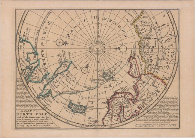
“A Map of the North Pole with All the Territories That Lye Near It, Known to Us &c. According to the Latest Discoveries, and Most Exact Observations. Agreeable to Modern History”
Map Maker:
Herman Moll
This unusual map depicts the North Pole and shows ... (full text available to subscribers)
| Item Detail |
| |
| |
MapMaker: |
Herman Moll
|
|
| |
| |
Subject: |
North Pole |
|
| |
Period/Size: |
1732 / 8.0" x 10.9" (20.4 x 27.7 cm)
|
|
| |
Color: |
Colored
|
|
| |
Condition: |
(A) A nice impression on a watermarked sheet with faint toning. There is archival tape reinforcing the centerfold to repair a short separation at bottom. (condition help) |
|
| |
Source: |
Atlas Minor |
|
| |
References: |
Kershaw #408; Shirley (BL Atlases) T.MOLL-9b. |
|
| |
|
|
| Sales Information |
| |
| |
Price: |
|
|
| |
| |
Offered by: |
Old World Auctions |
|
| |
Catalog: |
Auction No. 155 - Antique Maps, Charts, Atlases & Globes (9278) |
|
| |
Lot/Item #: |
42 |
|
| |
| |
Date: |
11/2015
|
|
| |
| |
|
Antique Maps - Valuation and Pricing, Descriptions, Resources |
|
Home |
Information |
Search |
Register |
Contact Us |
Site Map
Americana Exchange, Inc. © 1999 - 2024 Americana Exchange, Inc.. All rights reserved.
OldMaps.com, the OldMaps.com logo and
AMPR are service marks or registered service marks of Americana Exchange, Inc..
|