Title:
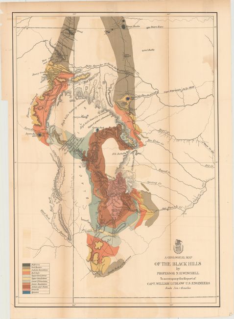
“A Geological Map of the Black Hills, by Professor N. H. Winchell, To Accompany the Report of Capt. William Ludlow, U.S. Engineers”
Map Maker:
U.S. Corps of Engineers
In the summer of 1874, Custer was tasked with reco... (full text available to subscribers)
| Item Detail |
| |
| |
MapMaker: |
U.S. Corps of Engineers
|
|
| |
| |
Subject: |
Dakota Territory |
|
| |
Period/Size: |
1875 / 25.0" x 17.5" (63.5 x 44.5 cm)
|
|
| |
Color: |
Colored
|
|
| |
Condition: |
(B) Issued folding and now flattened and backed with tissue to reinforce and repair a few short fold separations. Light toning along the folds and light color offsetting. (condition help) |
|
| |
Source: |
Report of a Reconnaissance of the Black Hills of Dakota |
|
| |
References: |
Wheat [TMW] #1251. |
|
| |
|
|
| Sales Information |
| |
| |
Price: |
|
|
| |
| |
Offered by: |
Old World Auctions |
|
| |
Catalog: |
Auction No. 155 - Antique Maps, Charts, Atlases & Globes (9278) |
|
| |
Lot/Item #: |
248 |
|
| |
| |
Date: |
11/2015
|
|
| |
| |
|
Antique Maps - Valuation and Pricing, Descriptions, Resources |
|
Home |
Information |
Search |
Register |
Contact Us |
Site Map
Americana Exchange, Inc. © 1999 - 2024 Americana Exchange, Inc.. All rights reserved.
OldMaps.com, the OldMaps.com logo and
AMPR are service marks or registered service marks of Americana Exchange, Inc..
|