Title:
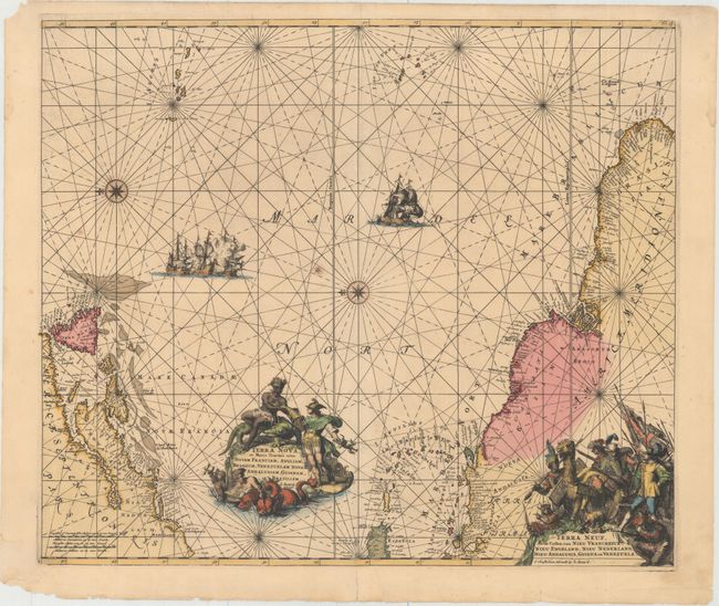
“Terra Nova, ac Maris Tractus circa Novam Franciam, Angliam, Belgium, Venezuelam Novam Andalusiam, Guianam et Brasiliam / Terra Neuf, en de Custen van Nieu Vranckryck, Nieu Engeland, Nieu Nederland, Nieu Andalusia, Guiana en Venezuela”
Map Maker:
Renard/De Wit
Magnificent sea chart of the western Atlantic Ocea... (full text available to subscribers)
| Item Detail |
| |
| |
MapMaker: |
Renard/De Wit
|
|
| |
| |
Subject: |
Atlantic Ocean |
|
| |
Period/Size: |
1715 / 19.1" x 22.2" (48.6 x 56.4 cm)
|
|
| |
Color: |
Colored
|
|
| |
Condition: |
(B+) A fine impression with original color in the map and later color in the cartouches. There is a small burn hole near the center of the map, and centerfold separations that enter map 0.5" at top and 1.5" at bottom have been archivally repaired. In th (condition help) |
|
| |
Source: |
Atlas de la Navigation et du Commerceģ |
|
| |
References: |
Burden #467; McCorkle #675.9; Shirley (BL Atlases) M.REN-1a. |
|
| |
|
|
| Sales Information |
| |
| |
Price: |
|
|
| |
| |
Offered by: |
Old World Auctions |
|
| |
Catalog: |
Auction No. 155 - Antique Maps, Charts, Atlases & Globes (9278) |
|
| |
Lot/Item #: |
395 |
|
| |
| |
Date: |
11/2015
|
|
| |
| |
|
Antique Maps - Valuation and Pricing, Descriptions, Resources |
|
Home |
Information |
Search |
Register |
Contact Us |
Site Map
Americana Exchange, Inc. © 1999 - 2024 Americana Exchange, Inc.. All rights reserved.
OldMaps.com, the OldMaps.com logo and
AMPR are service marks or registered service marks of Americana Exchange, Inc..
|