Title:
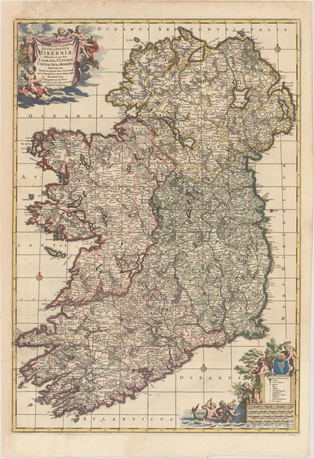
“Novissima ac Prae Caeteris Alus Accuratissima Regni et Insulae Hiberniae Delineatio, in qua sunt Lagenia, Ultonia, Connachia, et Momonia Provinciae...”
Map Maker:
Frederick de Wit
This handsome two-sheet map of Ireland is filled w... (full text available to subscribers)
| Item Detail |
| |
| |
MapMaker: |
Frederick de Wit
|
|
| |
| |
Subject: |
Ireland |
|
| |
Period/Size: |
1680 / 28.1" x 19.8" (71.4 x 50.3 cm)
|
|
| |
Color: |
Colored
|
|
| |
Condition: |
(A) A dark, crisp impression with a couple of minor spots, a tiny hole in Dingle Bay, and a professionally repaired tear that just enters map border at bottom. The left margin has been expertly extended to accommodate framing. (condition help) |
|
| |
Source: |
|
|
| |
References: |
|
|
| |
|
|
| Sales Information |
| |
| |
Price: |
|
|
| |
| |
Offered by: |
Old World Auctions |
|
| |
Catalog: |
Auction No. 155 - Antique Maps, Charts, Atlases & Globes (9278) |
|
| |
Lot/Item #: |
446 |
|
| |
| |
Date: |
11/2015
|
|
| |
| |
|
Antique Maps - Valuation and Pricing, Descriptions, Resources |
|
Home |
Information |
Search |
Register |
Contact Us |
Site Map
Americana Exchange, Inc. © 1999 - 2024 Americana Exchange, Inc.. All rights reserved.
OldMaps.com, the OldMaps.com logo and
AMPR are service marks or registered service marks of Americana Exchange, Inc..
|