Title:
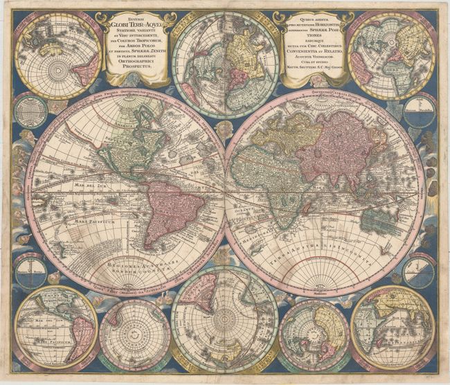
“Diversi Globi Terr-Aquei Statione Variante et Visu Intercedente, per Coluros Tropicorum...”
Map Maker:
Matthaus Seutter
This is one of the most graphic 18th century world... (full text available to subscribers)
| Item Detail |
| |
| |
MapMaker: |
Matthaus Seutter
|
|
| |
| |
Subject: |
World |
|
| |
Period/Size: |
1742 / 19.7" x 23.0" (50.1 x 58.5 cm)
|
|
| |
Color: |
Colored
|
|
| |
Condition: |
(B) A nice impression with attractive color and some old manuscript ink stains in the southern portions of the two main hemispheres. There are professional repairs to several separations and short tears along the centerfold, as well as a few small chips (condition help) |
|
| |
Source: |
Atlas Novus |
|
| |
References: |
Portinaro & Knirsch #119; Shirley (BL Atlases) T.SEU-2a #3. |
|
| |
|
|
| Sales Information |
| |
| |
Price: |
|
|
| |
| |
Offered by: |
Old World Auctions |
|
| |
Catalog: |
Auction No. 157 - Antique Maps, Charts, Atlases & Globes (9290) |
|
| |
Lot/Item #: |
30 |
|
| |
| |
Date: |
05/2016
|
|
| |
| |
|
Antique Maps - Valuation and Pricing, Descriptions, Resources |
|
Home |
Information |
Search |
Register |
Contact Us |
Site Map
Americana Exchange, Inc. © 1999 - 2024 Americana Exchange, Inc.. All rights reserved.
OldMaps.com, the OldMaps.com logo and
AMPR are service marks or registered service marks of Americana Exchange, Inc..
|