Title:
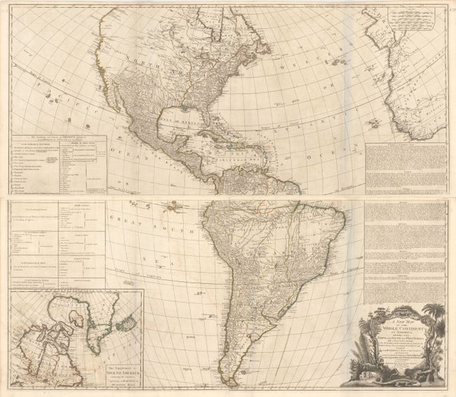
“A New Map of the Whole Continent of America, Divided into North and South and West Indies. With a Descriptive Account of the European Possessions, as Settled by the Definitive Treaty of Peace…”
Map Maker:
Sayer & Bennett
This impressive, 4-sheet, large-scale map of North... (full text available to subscribers)
| Item Detail |
| |
| |
MapMaker: |
Sayer & Bennett
|
|
| |
| |
Subject: |
Western Hemisphere - America |
|
| |
Period/Size: |
1777 / 20.4" x 47.0" (51.9 x 119.4 cm)
|
|
| |
Color: |
Colored
|
|
| |
Condition: |
(B+) Original outline color on watermarked paper with light offsetting. There are bluish lines along several folds that are caused by our scanner and do not appear on the map itself. (condition help) |
|
| |
Source: |
The General Atlas |
|
| |
References: |
Stevens & Tree (MCC-39) #3c. |
|
| |
|
|
| Sales Information |
| |
| |
Price: |
|
|
| |
| |
Offered by: |
Old World Auctions |
|
| |
Catalog: |
Auction No. 157 - Antique Maps, Charts, Atlases & Globes (9290) |
|
| |
Lot/Item #: |
86 |
|
| |
| |
Date: |
05/2016
|
|
| |
| |
|
Antique Maps - Valuation and Pricing, Descriptions, Resources |
|
Home |
Information |
Search |
Register |
Contact Us |
Site Map
Americana Exchange, Inc. © 1999 - 2024 Americana Exchange, Inc.. All rights reserved.
OldMaps.com, the OldMaps.com logo and
AMPR are service marks or registered service marks of Americana Exchange, Inc..
|